Weather in Australia: Record-warm seas, heat waves, floods, and cyclones
This week’s news headlines are once again dominated by Australia’s weather, with severe thunderstorms in NSW, a rapidly developing cyclone in Western Australia, and ongoing flooding in Queensland.
Southern states are baking in yet another heatwave, while the north and east are being soaked.
Wednesday’s temperatures in South Australia surged up to 18 degrees Celsius above normal, setting a new state record for February at 48.7 degrees Celsius at Oodnadatta.
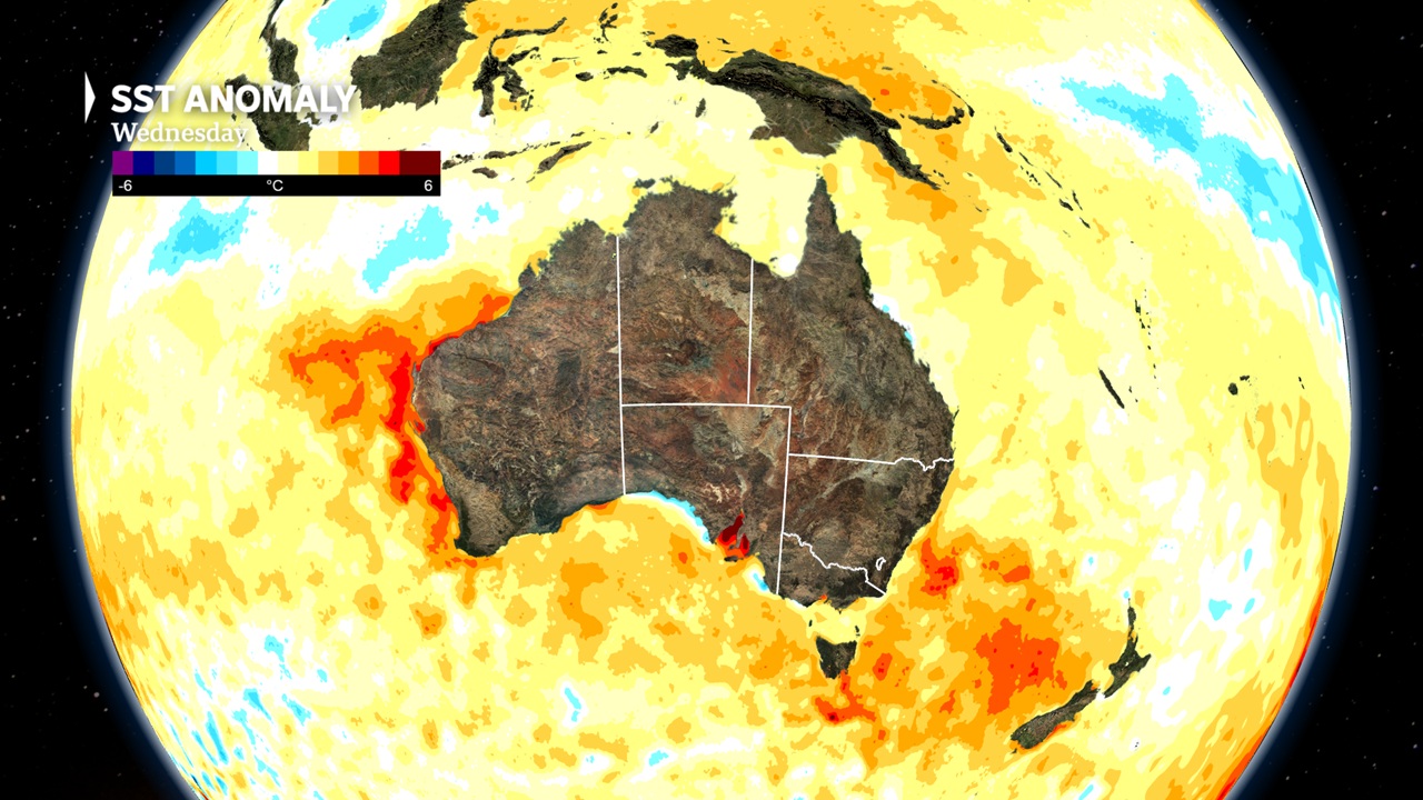
Sea Surface Temperature Anomaly
The majority of extreme events this month are being made worse by unusually warm waters off our coastlines, even though February is still the peak severe weather season.

In Australian waters, the average sea surface temperature in January was 24.6C, which was more than 1C warmer than the long-term average and the warmest January temperature ever recorded.
Australia has experienced record-warm seas for four consecutive months, a trend that has persisted into February, thanks to the extraordinary warmth.
At the moment, the most notable departures from the norm occur off the coasts of Western Australia and New South Wales, where temperatures can rise by up to 3 degrees Celsius.
Located just above the 26.5C threshold east of Sydney, the Tasman Sea’s waters are so warm that they could potentially support the formation of a tropical cyclone.
Severe weather usually requires more than one ingredient, but because of increased evaporation, the abundance of ocean heat is contributing to the events.
Since the atmosphere can hold 7% more water for every degree Celsius that air temperatures rise, warm waters and climate change essentially cause more water to enter the atmosphere and more to be held above ground waiting to precipitate out as rainfall.
A record February south-east heatwave
Heatwaves continue to affect Australia in February, following the country’s second-hottest December–January on record.
A fiery northerly off the interior is causing temperatures this week to soar well above 40 degrees Celsius all the way down to the South African coastline.
Wednesday’s highs in Adelaide ranged from 41 to 44 degrees Celsius, with West Terrace recording 43.3 degrees, which was only 1 degree Celsius below a February record.
Incoming Antarctic cold air
The cool winds, which originated far south near Antarctica, will cause a significant temperature drop of up to 20C in 48 hours, in contrast to most mid-summer changes.
After reaching a high of slightly below 40 degrees Celsius on Thursday, Melbourne can anticipate a swift drop to just 18 degrees this weekend as the cooler air moves eastward through South Africa.
Even though it’s summer, the air will be cold enough this weekend for Tasmania to see highland snow, and on Saturday night, there may be a brief dusting of the mainland alps.
Cyclone Zelia
Tropical Cyclone Zelia is likely to be the first system to make landfall in the 2024–25 Australian cyclone season. Tropical lows and cyclones are now more common on the daily weather maps following a sluggish start to the wet season and the most recent monsoon onset on record.
Ocean temperatures above 31C off the north coast of Washington helped Zelia gain strength through Wednesday. The system is expected to continue to intensify until it crosses the coast late Friday, though the position and timing of the modeling are still very uncertain.
Although it’s too soon to predict the exact impact, Cyclone Zelia is currently an average-sized system by international standards, with a tight cyclone-strength wind radius that stretches between 100 and 150 kilometers from the center.
Victoria heatwave, wildfire, Storms and flash flooding?!
In the last couple of days Victoria has declared a heatwave and a complete fire ban in areas that have already burned, as an uncontrolled bushfire rages in the Otways. Heavy rainfall has pounded eastern and northeastern regions of Victoria a few days earlier, due to an “unusual” upper-low pressure system, according to the Bureau of Meteorology (BOM).
See also Tasmanian bushfires threaten ancient forests (Again)
About the Author: CLIMATE STATE
POPULAR
COMMENTS
- The risk with the path to a hothouse Earth | Climate State on Climate Tipping Points Existential Threat to Our Life Support Systems
- Robert Schreib on Electricity generation prices may increase by as much as 50% if only based on coal and gas
- Robert Schreib on China made a historic commitment to reduce its emissions of greenhouse gases
- Lee Nikki on COP30: Climate Summit 2025 – Intro Climate Action Event
- Hollie Bailey on Leaders doubled down on fossil fuels after promising to reduce climate pollution
This article is just a bunch of doom and gloom. Can’t we get some good news about the weather for once? It’s always about heatwaves and cyclones. So frustrating!