Tasmanian bushfires threaten ancient forests (Again)
A grove that is home to the oldest known Huon pine, which is thought to be 3,000 years old, is within meters of a bushfire that is raging in the Takayna/Tarkine region of northwest Tasmania.
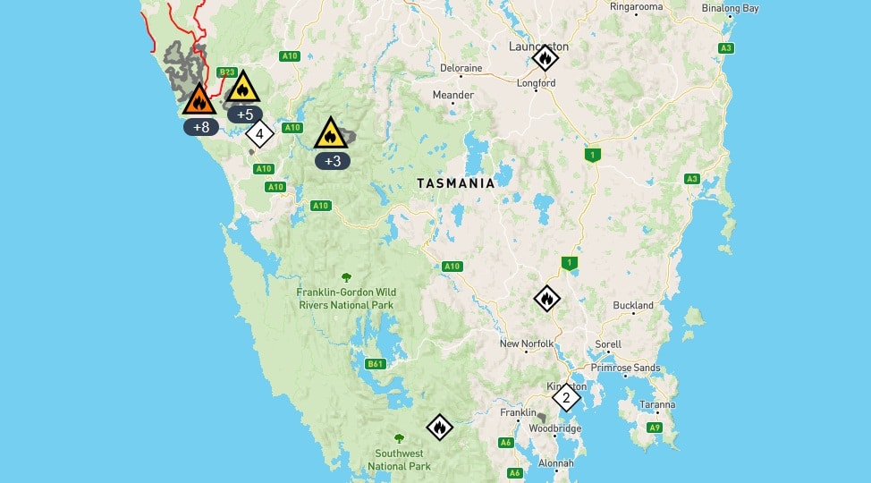
After a series of dry lightning strikes swept across the state on Monday afternoon, the Yellowband Plain fire is one of over a dozen known bushfires raging in the isolated central and western parts of the state.
Update January 13th, 2025: Smoke Billows From Bushfires in Tasmania
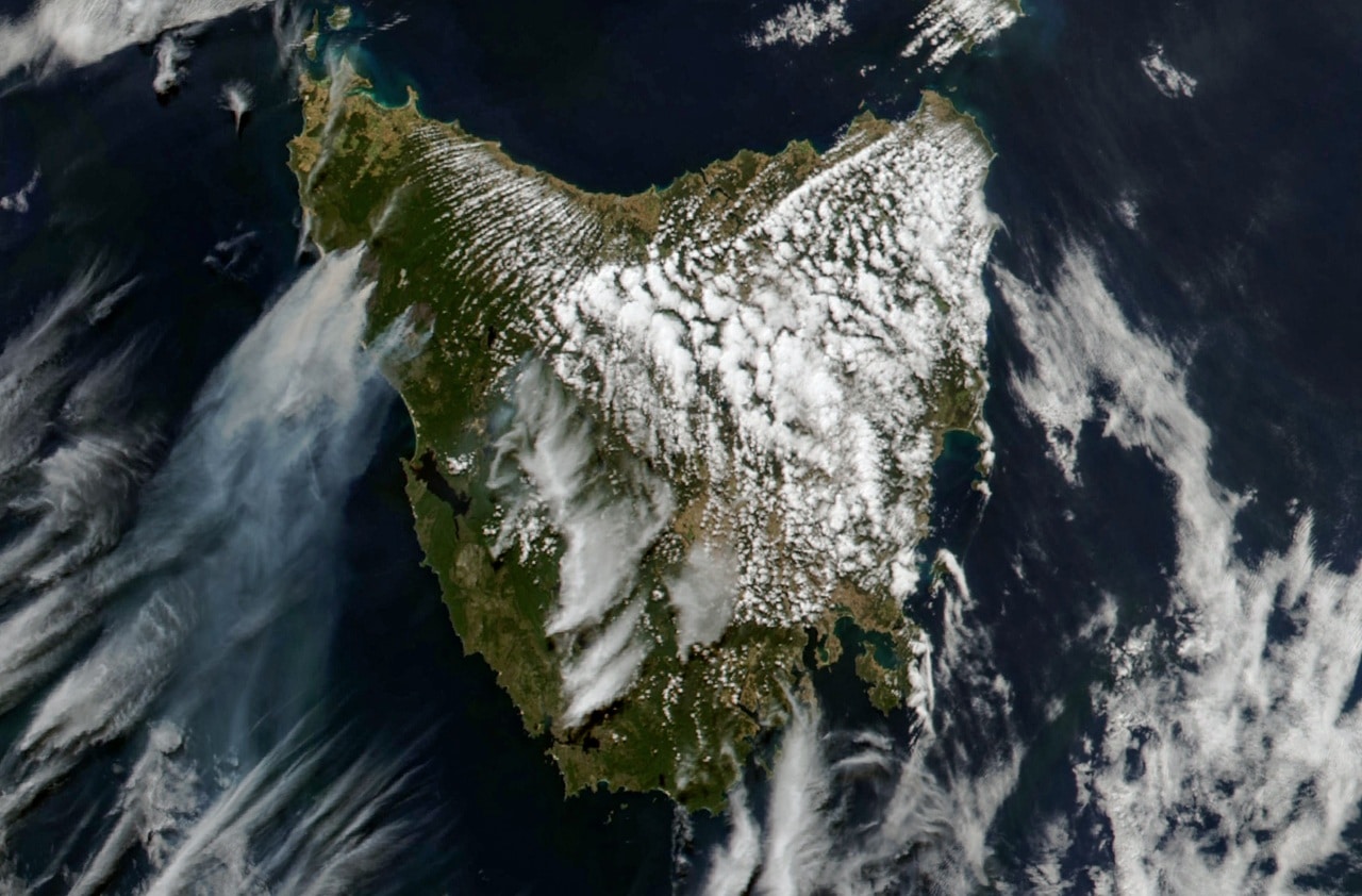
Smoke from the fires is visible in this image, acquired at about 4 p.m. local time (05:00 Universal Time) on February 12, 2025, by the MODIS (Moderate Resolution Imaging Spectroradiometer) instrument on NASA’s Aqua satellite.
In early February 2025, bushfires ignited in northwestern Tasmania, where they have continued to burn on the island for more than a week amid windy, warm, and dry conditions.
Starting on February 3, lightning strikes from dry thunderstorms ignited multiple fires in the state’s North West region, according to news reports. By February 12, more than a dozen fires had burned around 50,000 hectares (190 square miles).
An emergency warning, updated on February 13 by the Tasmanian government, indicated that one of the fires was progressing toward Sandy Cape, a popular spot for beach camping, and was expected to be “uncontrollable, unpredictable, and fast-moving.” (Note that Sandy Cape is covered with smoke in this view.)
Fire was also approaching the town of Corinna, where a “watch and act” warning remained in effect on February 13. Beekeepers have already abandoned hives near the town, according to news reports, where leatherwood trees supply nectar for bees that support much of the region’s honey industry.
According to a heatwave warning from Australia’s Bureau of Meteorology (BoM), much of the state’s west coast saw severe heatwave conditions on several days during the week of February 10. The region has also been exceptionally dry. For example, the past 12-month period has been the driest on record (since 1900) along the coastal areas near Sandy Cape.
Forecasts called for damaging winds with gusts of up to 90 kilometers (55 miles) per hour ahead of an approaching cold front. Cooler, wetter weather was expected toward the end of the week.
NASA Earth Observatory image by Michala Garrison, using MODIS data from NASA EOSDIS LANCE and GIBS/Worldview. Story by Kathryn Hansen.
A grove in Tasmania that contains the oldest-known Huon pine, estimated to be 3,000 years old is threatened by the wildfire in February 2025.
The fire partially encircled the Huon pine stand at its southern end, which contains dozens of old trees in a 1.2-kilometer-long grove.
-
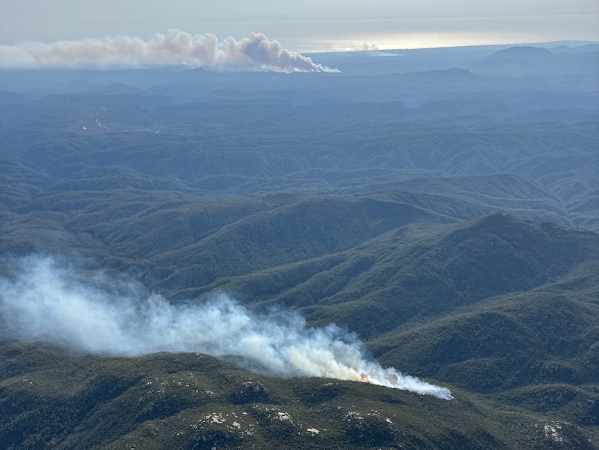
- A bushfire is burning at Yellowband Plains, Tasmania. Seen on February 5, 2025. (Supplied: DPFEM)
-
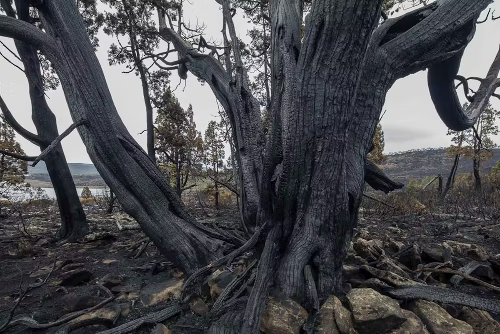
- A burned pencil pine during the alpine bushfires in Tasmania, 2016.
-
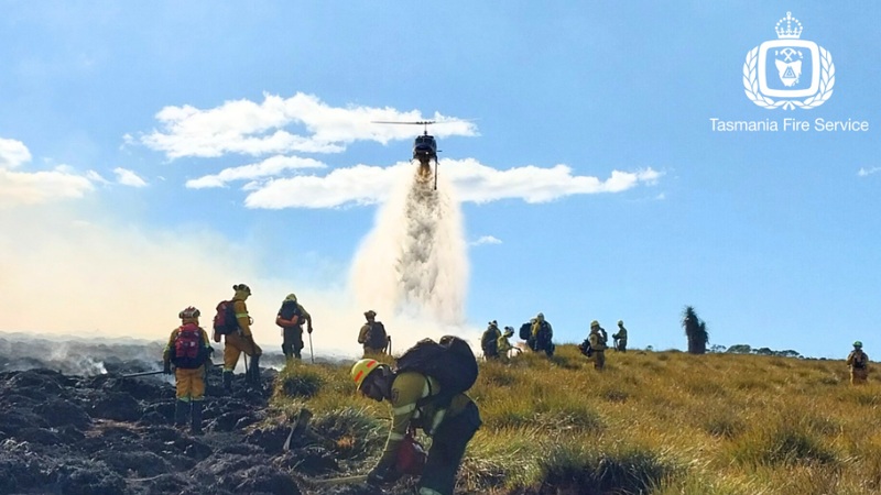
- Tasmania Fire Service battles West Coast bushfires at Canning Peak Fire.
-
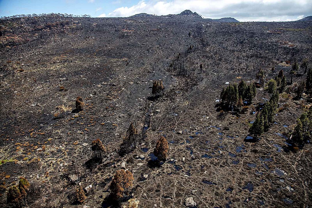
- Burnt alpine vegetation including pencil pines, Lake Mackenzie region, Tasmanian Wilderness World Heritage Area (2016).
-
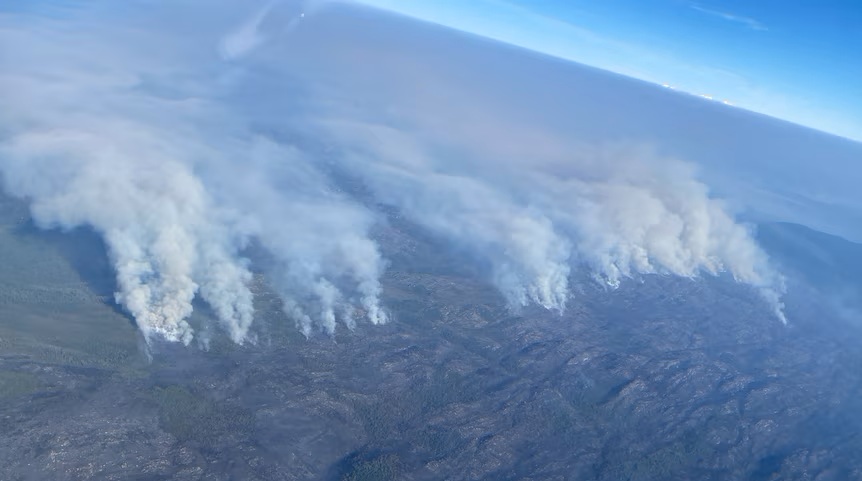
- Multiple bushfires have been seen during aerial spotting, February 2025. (Tasmania Fire Service)
A Huon pine in the grove is 187 centimeters in diameter, making it the oldest known to be between 2,500 and 3,000 years old, according to a 1997 study by the Institute of Antarctic and Southern Ocean Studies.
The only known stands of Tasmanian Huon pines that have not been affected by past forest logging are found close to the fireground.
Blazes have encroached on ecosystems that date back more than 180 million years.
Notable trees that were destroyed by recent bushfires
Recent bushfires in Tasmania have claimed a significant number of trees.
2019
Fifteen eucalypts that were at least 85 meters tall, or 280 cubic meters in volume, were destroyed in the 2019 Riveaux Road fire in the Huon Valley region south of Hobart.
It was estimated that one tree was 500 years old.
2018
Tasmania saw 210,000 hectares of bushfires during the 2018–19 season, with 95,430 of those hectares occurring in the wilderness World Heritage Area.
Recommendations were made after the fires were reviewed, including the need for remote area firefighters and a national conversation about fire management in remote areas.
Resourcing and Tasmanian authorities’ response to remote fires were altered as a result.
According to the review, “projected changes to climatic conditions” would cause fire seasons to get longer and more intense.
Widespread dry lightning strikes were the cause of the fire emergencies in 2016 and 2019.
Further, it was included to determine how fire affects fire-sensitive vegetation in terms of ecology and biodiversity, as well as securing long-term funding for fire modeling and assessment for Tasmania’s wilderness World Heritage Area.
2016
The Conversation: More than 72,000 hectares of western Tasmania have been burned by a cluster of bushfires, most of them ignited by a spectacular dry lightning storm that crossed the island on January 13.
The geographic scale of the fires can be seen on the Tasmanian Fire Service website. These fires pose an enormous, ongoing challenge to the fire service, with little immediate prospect of a speedy resolution to this crisis given the absence of soaking rains in the foreseeable future.
See also 2016 Tasmanian bushfires, 2014 record breaking heat and bushfires and 2013 Tasmanian bushfires.
A changing situation
Several recent fires have raged through ecosystems that are not at all suited to fire, relict forests from when Tasmania was a part of the Gondwana supercontinent, more than 180 million years ago, instead of consuming vast tracts of vegetation that are adapted to fire, like eucalyptus or banksia.
Pencil pines (Athrotaxis cupressoides) and King Billy pines (Athrotaxis selaginoides), which predominate in these high-altitude ecosystems, are destroyed by fires, which also destroy their seeds and burn the peaty soil in which they grow. It is nearly impossible for these old forests to naturally regenerate in the most affected areas.
A different climate regime
The Mirage: There is no evidence for a long-term trend. Instead, the data shows a shift from one stable fire climate regime to another.
We’re already seeing these changes play out. Whenever you see a news article about intense fires in areas not used to fire, that’s likely to be due to a shift in fire climate.
Observed increases in extreme fire weather driven by atmospheric humidity and temperature – Significant increases occurred over a quarter to almost half of the global burnable land mass. Decreasing relative humidity was a driver of over three-quarters of significant increases in FWI and ISI, while increasing temperature was a driver for 40% of significant trends. Trends in VPD were predominantly associated with increasing temperature. These trends are likely to continue, as climate change projections suggest global decreases in relative humidity and increases in temperature that may increase future fire risk where fuels remain abundant.
See also Tasmania Fire Service (Facebook)
About the Author: CLIMATE STATE
POPULAR
COMMENTS
- The risk with the path to a hothouse Earth | Climate State on Climate Tipping Points Existential Threat to Our Life Support Systems
- Robert Schreib on Electricity generation prices may increase by as much as 50% if only based on coal and gas
- Robert Schreib on China made a historic commitment to reduce its emissions of greenhouse gases
- Lee Nikki on COP30: Climate Summit 2025 – Intro Climate Action Event
- Hollie Bailey on Leaders doubled down on fossil fuels after promising to reduce climate pollution