Heatwave & Rare Weather Systems Tracking East to West
Just like we read left to right, most weather systems move left to right (West to East). Right now however, the weather pattern is out of whack, moving East to West, creating a monster tropical heatwave for a big chunk of the U.S.
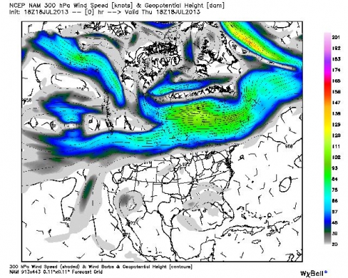
Climate Central: The heat wave that has built across the eastern U.S. — roasting cities from Memphis to Washington to Boston in a stifling blanket of heat and humidity — has had one strange characteristic that meteorologists cannot yet explain in a long-term climate context. Rather than moving west to east, as typical weather patterns do in the Northern Hemisphere, weather systems across the country have moved in the opposite direction, like a drunken driver on a dark stretch of highway, drifting from east to west during the past two weeks.
The heat wave that has built across the eastern U.S. — roasting cities from Memphis to Washington to Boston in a stifling blanket of heat and humidity — has had one strange characteristic that meteorologists cannot yet explain in a long-term climate context. Rather than moving west to east, as typical weather patterns do in the Northern Hemisphere, weather systems across the country have moved in the opposite direction, like a drunken driver on a dark stretch of highway, drifting from east to west during the past two weeks.
The air flow heading in the opposite direction across the U.S. is abnormal, as is the strength of the dome of high pressure. In recent years there have been numerous instances of strong and long-duration high pressure areas that have led to extreme weather events, including the Russian heat wave of 2010. According to NOAA, scientists are scheduled to meet at Oak Ridge National Laboratory in September to explore whether such “monster ridges” of high pressure are becoming more frequent or more intense as the atmosphere warms in response to manmade greenhouse gas emissions.
Jon Gottschalck acting chief of the Operational Prediction Branch at NOAA’s Climate Prediction Center, told Climate Central in an email that it’s not yet clear exactly how unusual the recent weather pattern has been, or what has been driving it. “Yes, the evolution you describe of the upper-level low and high pressure ridge moving east to west is definitely unusual. But it is not easy to quantify really how unusual,” he said.
“It would take considerable time to crunch through the data and utilize a methodology to accurately pick events like this that have occurred in the historical record and quantify [them]. From a climate-forcing perspective, there is no clear climate pattern right now that we can point to as a contributing factor and so we can really only attribute this evolution to natural internal variability, at least at this stage.”

About the Author: CLIMATE STATE
POPULAR
COMMENTS
- The risk with the path to a hothouse Earth | Climate State on Climate Tipping Points Existential Threat to Our Life Support Systems
- Robert Schreib on Electricity generation prices may increase by as much as 50% if only based on coal and gas
- Robert Schreib on China made a historic commitment to reduce its emissions of greenhouse gases
- Lee Nikki on COP30: Climate Summit 2025 – Intro Climate Action Event
- Hollie Bailey on Leaders doubled down on fossil fuels after promising to reduce climate pollution