Will a 2015 Arctic sea ice melt season during an El Nino year shatter previous records?
Sea ice melt season 2015
Last year a study reported that the Arctic sea ice melt season is getting longer.
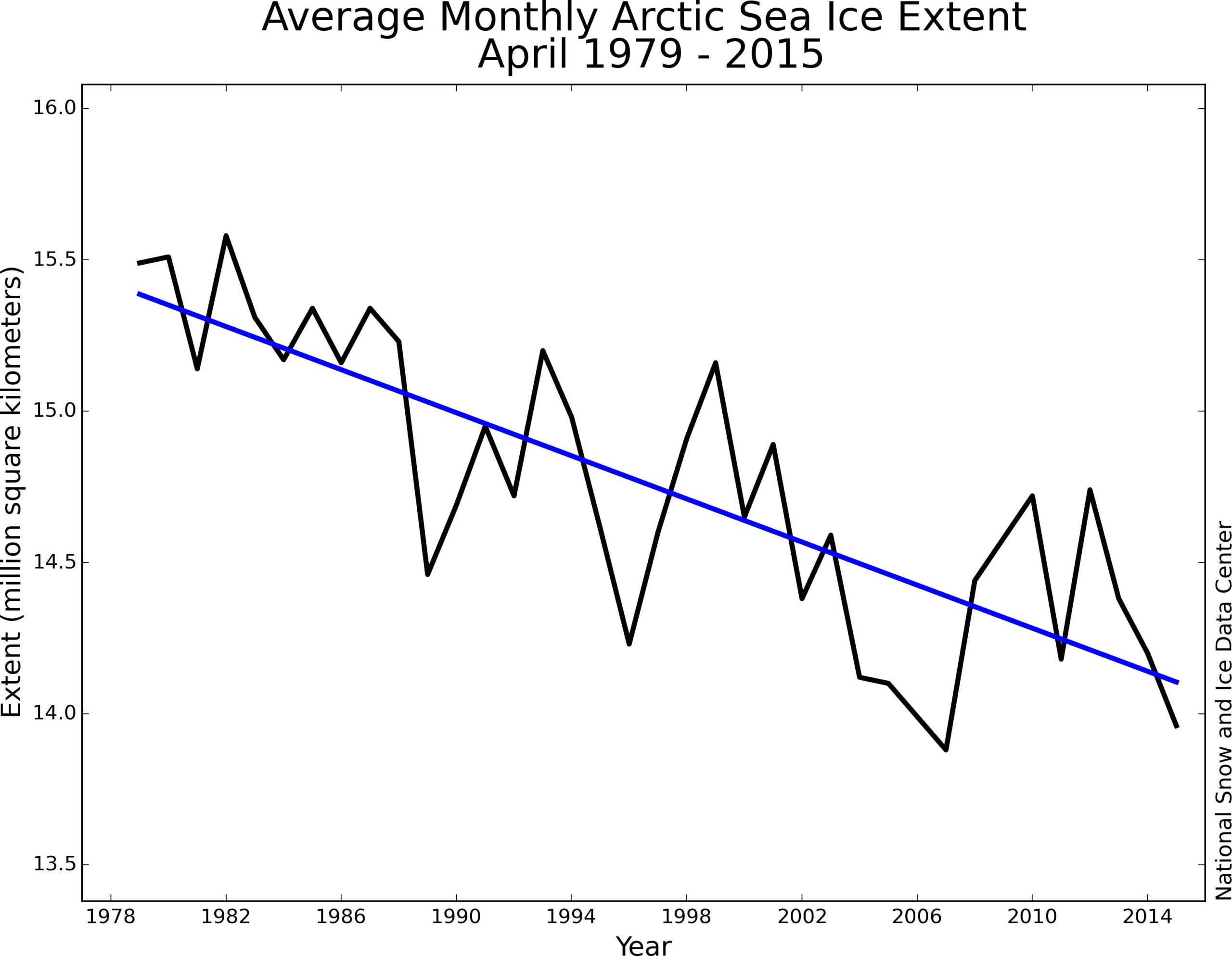
The situation for the state of the Arctic sea ice this year is already critical, since April 2015 set the 2nd lowest sea ice extent record (NSIDC).
A decline of 2.4% per decade relative to the 1981 to 2010 average. Arctic sea ice extent averaged for April 2015 was the second lowest in the satellite record for the month.
Previously in March, the NSIDC reported for the month of February
On February 25, 2015, Arctic sea ice extent appeared to have reached its annual maximum extent, marking the beginning of the sea ice melt season. This year’s maximum extent not only occurred early; it is also the lowest in the satellite record.
February was characterized by an unusual configuration of the jet stream, leading to warm conditions over the Pacific side of the Arctic that maintained low sea ice extent in the Bering Sea and the Sea of Okhotsk. Furthermore, since the last half of February through the middle of March, the Arctic Oscillation was in a strongly positive phase, with index values exceeding 5.0 for several days in the first week of March. This has been expressed as a strong Icelandic Low, a semi-permanent area of low atmospheric pressure found between Iceland and southern Greenland and extending into the Barents Sea. The strong Icelandic Low led to a pattern of surface winds over the Barents and Kara seas with an unusually strong component from the south.
Warm waters originating from The Blob, could potentially further intrude through the Bering Strait, and contribute through this pathway to further sea ice decline in the 2015 sea ice melt season.
The Blob, a large mass of warm water in the Pacific Ocean off the coast of North America. It was first detected in late 2013 and is expected to continue throughout 2015. It is an anomaly in ocean conditions and is considered to have a role in the formation of the unusual weather conditions felt in the Pacific Coast.
A NOAA scientist noted in September 2014, based on ocean temperature records, that the North Pacific Ocean never experienced temperatures this warm for so long.
Though researchers disagree over just what this blob portends, the phenomenon is drawing intense scrutiny from climate scientists and oceanographers. Canada senior climatologist David Phillips noted about the Alberta Canada winter season
“If that blob continues, if it stays warm … and then you add to that El Nino, it may compliment each other and then it may be the year winter is cancelled.”
El Niño
NOAA just announced – El Niño Advisory
There is an approximately 90% chance that El Niño will continue through Northern Hemisphere summer 2015, and a greater than 80% chance it will last through 2015.
Based on length of the melt season the IPCC (AR3) noted in 2001.
An increase in the length of the Arctic summer melting season between 1979 and 1998, also derived from satellite data. The shortest season was 1979 (57 days) and the longest was in 1998 (81 days) with an increasing trend of 5 days per decade (Smith, 1998, updated).
1998 was marked by the strongest El Nino that century.
On the record reduction in 1998 western Arctic Sea-ice cover (1999)
During summer 1998, record reductions in ice cover occurred in the Beaufort and Chukchi seas. Open water formed earlier than in prior years, and September ice extent in this region was 25 percent less than the previous minimum for 1953–1997. Seven percent of the Arctic Basin that had been perennially ice covered was ice-free in 1998.
Even though sea ice reached record levels in parts of the Arctic in 1998, the next year (1999) broke previous ice extent records.
What can we expect in 2015, with already record breaking decline of Arctic sea ice?
Background
A study from 2011 (Trends and variability in summer sea ice cover in the Canadian Arctic based on the Canadian Ice Service Digital Archive, 1960–2008 and 1968–2008) stated
Between 1979 and 2006, pan-Arctic reductions in the annual average Arctic sea ice extent estimated from the passive microwave satellite record were on the order of 3% to 4% decade−1, and seasonally, the largest reductions have occurred in summer at a rate of 6.2% decade−1 [Parkinson and Cavalieri, 2008]. These hemispheric wide reductions in Arctic sea ice have been linked to changes in the atmosphere [e.g., Serreze et al., 2007], ocean [e.g., Maslowski et al., 2001] as well the phase and strength of large-scale climate oscillations namely the Arctic Oscillation (AO) [e.g., Rigor and Wallace, 2004] and the El Niño-Southern Oscillation (ENSO) [e.g., Liu et al., 2004].
Further reading
Related
About the Author: CLIMATE STATE
POPULAR
COMMENTS
- Robert Schreib on Electricity generation prices may increase by as much as 50% if only based on coal and gas
- Robert Schreib on China made a historic commitment to reduce its emissions of greenhouse gases
- Lee Nikki on COP30: Climate Summit 2025 – Intro Climate Action Event
- Hollie Bailey on Leaders doubled down on fossil fuels after promising to reduce climate pollution
- Malcolm R Forster on Mythbusters tests global warming theory – does CO2 warm air?

[…] Will a 2015 Arctic sea ice melt season during an El Nino year shatter previous records? http://climatestate.com/2015/05/15/will-a-2015-arctic-sea-ice-melt-season-during-an-el-nino-year-sha… […]
[…] Also read my other post in those regards: Will a 2015 Arctic sea ice melt season during an El Nino year shatter previous records? […]