Arctic Sea Ice Hits Record Low
By Robert Scribbler: While the British Isles suffered a 60 day string of hurricane-force storms delivering the worst rain and wind events since 1766, while the Eastern US suffered numerous and crippling severe storm events, and while California flirted with a 500 year drought before succumbing to a deluge of 11 inch in one day rainfall, the Arctic has been outrageously warm for winter.
Throughout the past three months, daily averages for the Arctic have ranged, overall, between 3 and 7 degrees Celsius hotter than normal. All while regional averages for locations within the Arctic often hit more than 20 degrees Celsius above average as a large pool of heat drifted about the northern polar zone.
By this week, that excess heat had finally done its work on sea ice, setting a new daily record low for this time of year.
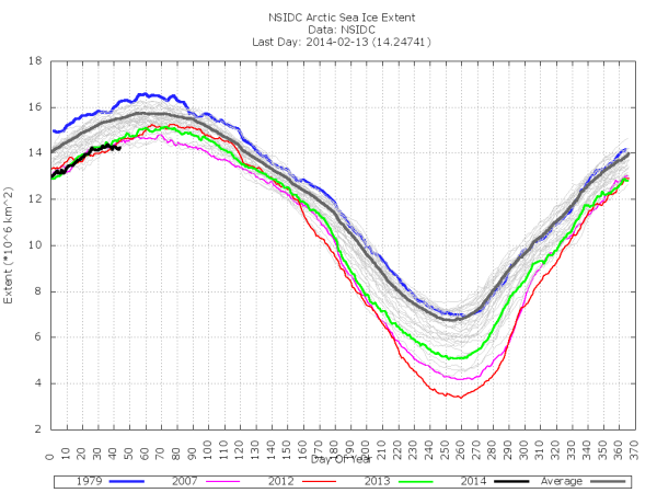

As of February 12, sea ice extent had fallen to a record low for the date of 14.2 million square kilometers only nudging slightly higher to 14.24 million square kilometers by the 13th. According the Cryosphere Today, sea ice area also hit a new record low of 12.51 million square kilometers on the 11th before nudging slightly higher than 2012′s record lows on the 12th and 13th.
These, very low, sea ice area and extent measures are comparable to those seen during mid-May in 1979. If the extreme heat continues, we could see an end to the annual freeze season in February. But such an event would be rare and unprecedented. So it is too early to call.
Currently, conditions remain far, far warmer than normal with temperatures in the high Arctic are flirting with values typically seen during May:
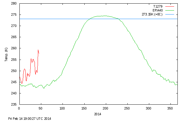
The recent high temperature anomaly for this furthest north region is extraordinary with averages for the zone about 17 degrees Celsius above the norm. And all that extra heat is translating into record low or near record low sea ice on the ocean surface.
As mentioned in numerous other blog posts, these extraordinary temperature values, a part of an average Arctic climate now hotter than at any time in at least 44,000 years, has profound impacts on world weather. It drives severe changes to the Jet Stream that can collapse the polar vortex and push Arctic-type storms into the US, while ski slopes in typically frigid Sochi, Russia melt. It can turn the North Atlantic into a breeding ground for severe storms that last for more than 40 days and 40 nights in Great Britain. It can spark winter wildfires in Norway. And it can set off record heatwaves, January thaws and snow melt spurring avalanches that cut off entire cities in Alaska.
These kinds of difficult to manage changes are exactly what we would expect from the initial ramping up of human-caused warming. An intensification that features Arctic temperatures which drive record low sea ice totals during winter and result in Arctic temperature anomaly spikes that look like this:
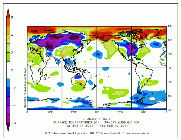
If you think the world here looks like it has a fever, then you are right. And this, along with the severe weather changes we have witnessed this winter are exactly what we can expect from a world which humans are causing to rapidly warm.
Related

Support Earth Climate

About the Author: EARTH CLIMATE
Recent Comments
- Gemma on The Dynamics of Greenland Ice Sheet Melt: Atmospheric Drivers and Feedback Loops
- The Dynamics of Greenland Ice Sheet Melt: Atmospheric Drivers and Feedback Loops | Earth Climate on Melt lakes on Greenland’s Glaciers
- The Dynamics of Greenland Ice Sheet Melt: Atmospheric Drivers and Feedback Loops | Earth Climate on Exceptional 2012 Greenland Ice Melt Caused By Jet Stream Changes That May Be Driven By Global Warming
- Gemma on Emergency Blankets: First Aid Equipment and Heat Protection #Lifehack
- Haiku on Alpine glaciers: Very severe ice loss
Support
We create visually compelling, accessible science content that transforms complex research into engaging videos and articles, helping millions understand the discoveries shaping our world. Paypal | Patreon
Does not look like a big deal, especially since this is only one source, and others show higher values for sea ice extent (by a million square km). These values are less than 10% below the average values.
http://ocean.dmi.dk/arctic/icecover.uk.php
It is not surprising that the Arctic is about 6C above average. That is an offside to the Northern Hemisphere being a similar amount below average. This tends to happen when the jet stream drops further south; the cold, Arctic air travels south, being replaced by warmer, Pacific air. The warmer Arctic has resulted in less ice buildup. However, the colder northern latitudes is likely to result in much less ice melt this summer, leading to higher sea ice minimum values this year compared to last.
Dan, the jet is not static and the DK site uses a different baseline. And you ignore this item here “The recent high temperature anomaly for this furthest north region is extraordinary with averages for the zone about 17 degrees Celsius above the norm.”
[…] Arctic Sea Ice Hits Record Low […]