USGS: Climate-Hydrate Interactions
The U.S. Geological Survey Gas Hydrates Project Release URL | […]
Date Posted:
January 3, 2014
The U.S. Geological Survey Gas Hydrates Project
Release URL | Access date: January 3rd 2014.
Climate studies in the USGS Gas Hydrates Project have become increasingly important since 2007 and focus on the impact of Late Pleistocene to contemporary climate change on the stability of methane hydrate deposits. The goal is to determine how much, if any, methane hydrate is currently dissociating on Earth in response to climate change processes and to estimate the amount of methane that would directly reach the atmosphere from such degassing. Methane is a potent greenhouse gas. If large amounts of methane were to reach the atmosphere from degassing gas hydrates, global warming might be exacerbated. In Earth’s deep past, methane has been a potentially important agent during other periods of rapid warming.
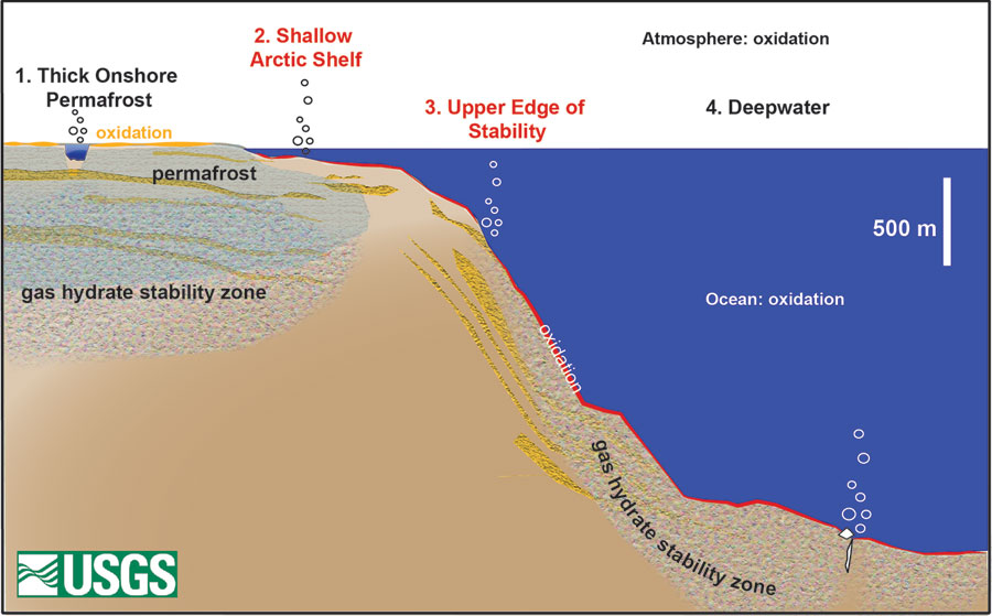
Presently, much of the methane released from dissociating gas hydrates is injected into the deep oceans, where it dissolves and may be oxidized to carbon dioxide. This carbon dioxide does have an effect on ocean chemistry (contributing to acidification), and some of the carbon dioxide may reach the atmosphere in a few hundred years’ time. A fraction of the methane emitted from shallow (< 100 m water depth) seafloor can reach the atmosphere directly, but methane hydrate is not the primary source of methane at these water depths. Only in circum-Arctic regions where some remnant permafrost remains on the continental shelves could methane emitted at shallow water depths possibly be derived from gas hydrates.
The Arctic is experiencing climate change at a rapid rate compared to most other places on Earth. The USGS Gas Hydrates Project has therefore focused on studying both permafrost-associated and deepwater marine gas hydrates in the US Arctic. The USGS also studies climate-sensitive components of the deepwater gas hydrate system on other continental margins since upper continental slope hydrates are globally sensitive to small perturbations in intermediate ocean water temperatures.
There are two populations of gas hydrates in the circum-Arctic Ocean region. Deepwater marine gas hydrates in the Arctic Ocean are subject to the same stability conditions and distribution constraints as deepwater gas hydrates in other oceans. In the Arctic Ocean, the updip extent of gas hydrates on the upper continental slope is shallower than in other locations due to the presence of cold intermediate waters though. At high latitudes, methane hydrates also occur at depths of ~225 m or greater in and beneath continuous permafrost. On contemporary Earth, such permafrost-associated hydrates may be found both onshore and beneath parts of Arctic Ocean continental shelves offshore. The offshore permafrost is termed ‘relict’ or subsea permafrost. This relict permafrost formed during the Late Pleistocene cold period, when the present-day Arctic Ocean continental shelves were exposed due to low sea levels. As sea level has risen (by approximately 100 m) over the past 15,000 years, the shelves have been inundated, exposing the former surface sediments (now at the seafloor) to temperatures ~15C warmer than they experienced when they were exposed sub-aerially.
Researchers used to believe that the subsea permafrost might still extend as far offshore as the 100 m isobath, but studies from the US Beaufort Sea and the Kara Sea are challenging this assumption. These results show that the offshore extent of contemporary permafrost is limited to a few tens of kilometers and confined to relatively shallow waters (few tens of meters). If the maximum extent of subsea permafrost was once at the 100 or 120 m isobath, most subsea permafrost on some parts of the Arctic Ocean margin has already thawed, and any associated methane hydrate would have likely dissociated long ago. Future climate warming (and ice-free conditions) may exacerbate thawing of the remaining subsea permafrost, but thousands of years are still required to significantly perturb sediment temperatures hundreds of meters below the seafloor, the minimal depth at which gas hydrates can occur. Even when these gas hydrates dissociate, most the gas will remain in the sediments unless there are pathways to facilitate its migration vertically or laterally.
Permafrost-associated gas hydrates differ significantly from deepwater gas hydrates in several ways. The host sediments for permafrost-associated gas hydrates are variegated terrestrial deposits, and the gas hydrates are typically concentrated only in coarse-grained layers. Permafrost gas hydrates are relatively uncommon compared to nearly ubiquitous deepwater gas hydrates, which form in near-seafloor sediments almost anywhere that microbial methane is produced in sufficient quantities from degradation of organic carbon. The explanation for the relative paucity of permafrost-associated gas hydrates lies in the source of gases. In the deep ocean, microbial methane generated in or having migrated to the shallow sedimentary section routinely forms gas hydrate. In permafrost areas, methane hydrate is not stable until about 225 m depth, and shallower (usually microbial) methane is therefore not incorporated into gas hydrate. At depths of 225 m and greater, most of the methane is thermogenic and spatially associated with underlying conventional gas reservoirs. During Late Pleistocene cooling events, some of the gas from these reservoirs was trapped within the hydrate stablity zone and “froze” in gas hydrate. To date, verifiable permafrost-associated gas hydrate deposits have not been found without an associated conventional gas reservoir.
To determine the potential for release of methane due to warming of gas hydrate deposits requires a sound estimate of the amount of methane sequestered in gas hydrates. The material outlined here is mostly covered in Ruppel (2011). Global estimates of the amount of methane sequestered in gas hydrates vary, but a reliable modern estimate by DOE and USGS coauthors is 3×10^15 cubic meters of methane or ~1800 gigatons (Gt) of carbon. The most recent and exhaustive gas-in-place estimate (Johnson, Fire in the Ice, 2011) for global methane hydrates yields a value only slightly lower, comparable to ~1600 Gt carbon. Dickens has given an upper bound of 12,400 Gt carbon sequestered in global hydrates.
Scientists typically apportion about ~1% of global methane hydrate deposits to permafrost regions. Even if the proportion is as large as 2%, permafrost-associated gas hydrates in the entire circum-Arctic region sequester would sequester less than ~40 Gt of carbon for the accepted gas-in-place estimates or as much as 248 Gt for the upper bound of Dickens. One published study estimates a total of 780 Gt carbon in two pools of permafrost-associated gas hydrates on the East Siberian shelf alone.
Subsea Permafrost and Continental Shelf Methane Emissions: US Beaufort Sea
Published studies report water column methane supersaturation and elevated ocean-atmosphere methane flux on the East Siberian shelf, possibly due to the dissociation of gas hydrates as subsea permafrost thaws. There are numerous shallow methane sources on continental shelves in the Arctic Ocean (e.g., methane produced in shallow sediments by microbial processes, methane produced deeper in the section as organic carbon is released from thawing permafrost) though. Researchers are still testing whether there is a direct link between dissociation of methane hydrates and elevated water column methane concentrations or methane fluxes on parts of the Arctic Ocean continental shelf.
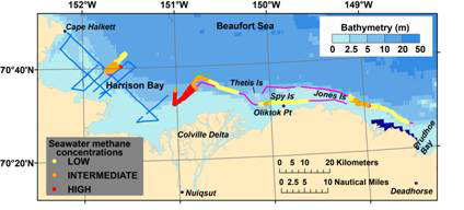
Motivated by these studies, the USGS Gas Hydrates Project has undertaken a multipronged effort to examine gas hydrate dynamics and methane distributions on the continental shelf in the US part of the Beaufort Sea. With the involvement of a postdoctoral fellow sponsored by the US Department of Energy (DOE) and the National Research Council, the USGS Gas Hydrates Project produced the first regional map of (relict) subsea permafrost on the US Beaufort Sea continental shelf, based on an analysis of legacy seismic data. The map revealed that the remaining subsea permafrost lies within 30 km of the shoreline and at water depths shallower than the 20 m isobath. If the subsea permafrost once extended to the present-day 100 m isobath and if gas hydrates occurred within or beneath that permafrost, then most of the hydrate that once existed in this area has by now dissociated.
Because gas hydrates lie so deep in the sediments, dissociation is most likely to leave the gas trapped in the sediments unless a pathway (e.g., fault, gas chimney) is available or forms to transport it to the seafloor. Seafloor cold seeps have been recognized in some locations on the shallow Arctic shelves, and the underlying seep plumbing systems are an important mechanism for transferring methane from deep sediments to the seafloor. Seeps are more common in areas of current or prior tectonic activity (e.g., Canadian Beaufort folded margin, East Siberian shelf failed rift systems) and may tap into populations of methane other than those associated with dissociating gas hydrates. In the Canadian Beaufort, the existence of gas hydrates has been proved through drilling, and research is underway to determine if pingo-like features on the shelf are leaking methane from dissociating gas hydrate. Based on cruises in 2010, 2011, and 2012, seeps are rare on the US Beaufort passive margin, even at the contemporary seaward extent of subsea permaforst where gas hydrate might be expected to be dissociating.
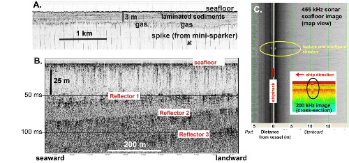
In 2010 and 2011, we conducted geophysical surveys on the inner shelf of the US Beaufort Sea to validate regional subsea permafrost findings, map seafloor morphology affected by ice and methane, and determine shallow subseafloor methane distributions. The USGS surveys revealed nearly ubiquitous shallow methane, most of which was likely produced in situ in the shallow sediments due to microbial degradation of organic carbon. The surveys did not find deep-seated vertical migration pathways as would be required to transfer methane derived from dissociating gas hydrate from deep sediments to the near-surface. In 2014 and 2015, Scripps Institute of Oceanography (Constable) will conduct controlled source electromagnetic surveys across the permafrost/no-permafrost transition on the US Beaufort Sea margin with logistical and scientific support from the USGS Gas Hydrates Project and funding from the US Department of Energy. The goal of these surveys is to determine whether subsea permafrost distribution as constrained by electromagnetic methods differs from that determined based on seismic analyses.
Mapping Methane Fluxes on the Beaufort Continental Shelf and Upper Continental Slope
The USGS Gas Hydrates Project mapped seawater and atmospheric methane and carbon dioxide concentrations on the US Beaufort Sea shelf and upper continental slope in 2011 and 2012 using cavity ringdown spectroscopy (CRDS) and collected coincidental data on environmental parameters. These data will be used to calculate methane flux at the ocean-atmosphere interface using established methods. The 2012 program also included real-time mapping of the carbon isotopic signature of methane and carbon dioxide in seawater (CRDS), determination of water column methane oxidation rates, and water sampling as a function of depth for direct determination of methane concentrations. The oxidation rate measurements were carried out in collaboration with University of California-Irvine.
In October 2012, the Gas Hydrates Project conducted sampling of near-surface seawater and multiple levels of air to determine methane and carbon dioxide concentrations and fluxes from the Chukchi Sea to the Amundsen Gulf aboard the USCG Healy. This was the first shipborne multilevel atmospheric marine boundary layer sampling for greenhouse gases. The experiment will be repeated in October 2013. The acquired data constrain ocean-atmosphere methane fluxes and gradients of methane and carbon dioxide in the atmospheric marine boundary layer for the Western Arctic Ocean, including parts of the deepwater Canada Basin.
Tracking Gas Hydrate Dynamics on the Upper Continental Slope of the US Beaufort Sea
If intermediate water temperatures are warming, then upper continental slope gas hydrates should be actively dissociating on the world’s ocean margins. The upper slope in circum-Arctic Ocean regions is of particular interest in light of documented warming of some water masses over the past several decades. In August 2012, the USGS Gas Hydrates Project acquired ~500 km of multichannel seismic data and Chirp data from the shelf to upper continental slope (1000 to 1500 m water depth) in the US Beaufort Sea. These were the first non-industry seismic surveys of this area in the modern era and provide an unprecedented data set to constrain the morphology of the upper feather edge of gas hydrate stability, thermal regimes on the upper continental slope, the location of possible relict gas hydrate beneath the shelf, and the loci of initiation of large-scale slope failures.
The USGS Gas Hydrates Project is also collaborating with academic partners on numerical modeling of gas hydrate dynamics in these areas and will conduct extensive 2014 coring across the upper feather edge of gas hydrate stability on the Beaufort continental slope with sponsorship from DOE.
This research serves as site survey for a proposed multiplatform Integrated Ocean Drilling Program study of Late Pleistocene to contemporary climate change on the US Beaufort continental shelf and slope. The IODP pre-proposal (#797), which highlights catching climate change in progress through the tool of the drill, was led by USGS Gas Hydrates Project personnel.
Methane Emission Mechanisms
With NSF sponsorship, the Gas Hydrates Project is collaborating with MIT Parsons Lab on the mechanisms for methane release from fine-grained sediments and the net flux of methane from temperate lakes. This work is conducted in a kettle lake close to Boston, where MIT has nearly 2 decades worth of data.
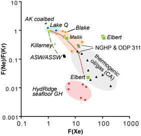
Fingerprinting Dissociating Gas Hydrate with Noble Gases
A major challenge to researchers is the lack of a technique able to distinguish methane released from recently dissociated gas hydrate from other populations of methane. This is particularly important on circum-Arctic continental shelves, where there are many possible sources of methane and where dissociation of methane hydrates would imply more serious perturbation of the sedimentary section during warming and inundation than would methane release from other sources. With Andrew Hunt of the USGS Noble Gas Facility in Denver, the USGS Gas Hydrates Project has been investigating the potential for noble gas characteristics to distinguish between gas recently dissociated from gas hydrates and other gas populations. The research has underscored the need for careful handling of hydrate samples, whose noble gas signatures change significantly during storage in liquid nitrogen.
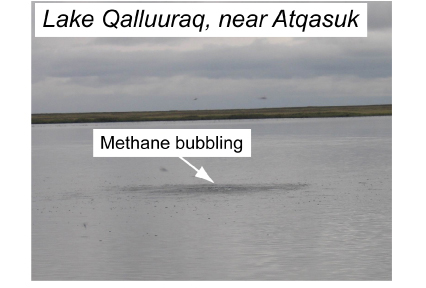
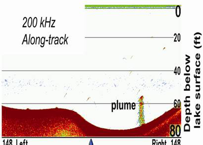
Thermokarst Lakes Emitting Methane
In 2009 and 2010, the USGS Gas Hydrates Project collaborated with the University of Alaska-Fairbanks to conduct geochemical, geophysical, and microbiological studies of thermokarst lakes (Lake Qalluuraq , Teshekpuk Lake, and others) that are releasing methane from the Alaskan North Slope. The methane that is venting from these lakes is unlikely to be derived from dissociating gas hydrates.
Related
Methane hydrates and global warming
Jan 02, 2014
One of the most obvious assumptions was that the increasing global warming has already extended into these regions of the North Atlantic. However, the investigations partly carried out with the German research submersible JAGO, pointed clearly to natural causes. “On one hand, we have found that the seasonal variations in temperature in this region are sufficient to push the stability zone of gas hydrates more than a kilometre up and down the slope,” Professor Berndt explains. “Additionally, we discovered carbonate structures in the vicinity of methane seeps at the seafloor”, Dr. Tom Feseker from MARUM adds. “These are clear indicators that the outgassing likely takes place over very long time periods, presumably for several thousand years”, Feseker continues.
Further Reading
- Brothers, L., P. Hart, and C. Ruppel, 2012, Minimum distribution of subsea ice-bearing permafrost on the US Beaufort Sea continental shelf, Geophys. Res. Lett., 39, L15501. Doi:10.1029/2012GL052222
- He, R. et al., Diversity of active aerobic methanotrophs along depth profiles of arctic and subarctic lake water column and sediments, The ISME Journal (2012) 6, 1937 1948; doi:10.1038/ismej.2012.34
- Hunt et al., 2013, Mass fractionation of noble gases in synthetic methane hydrate: Implications for naturally occurring gas hydrate dissociation , Chemical Geology, 339, 242-250
- Isaksen, I. S. A., M. Gauss, G. Myhre, K. M. Walter Anthony, and C. Ruppel, 2011. Strong atmospheric chemistry feedback to climate warming from Arctic methane emissions, Global Biogeochem. Cycles, 25, GB2002, doi:10.1029/2010GB003845.
- Pohlman, J. et al., 2011, Methane hydrate-bearing seeps as a source of aged dissolved organic carbon to the oceans, Nature Geoscience, 4, 37-41, 2011. Doi: 10.1038/ngeo1016.
- Pohlman, J. et al., 2012, Real-time mapping of seawater and atmospheric methane concentrations offshore of Alaska’s North Slope, Sound Waves (USGS newsletter).
- Ruppel, C., 2011, Methane Hydrates and Contemporary Climate Change, Nature Education Knowledge, 3(10):29.
- Ruppel, C., 2011, USGS Gas hydrates project convenes DOE workshop on climate-gas hydrates interactions, Fire in the Ice, DOE NETL newsletter, May edition, vol. 11(1), 18-20.
- Ruppel, C. and D. Noserale, 2012, Gas hydrates and climate warming–Why a methane catastrophe is unlikely, Sound Waves (USGS newsletter), cover story.
- Ruppel, C., Hart, P. and C. Worley, 2010, Degradation of subsea permafrost and associated gas hydrate offshore Alaska in response to climate change, Sound Waves, USGS newsletter, October/November edition, cover article
- Ruppel, C. et al., 2012, Methane dynamics associated with long-term climate change on the Alaskan Beaufort Sea inner shelf, Fire in the Ice, DOE NETL newsletter, vol. 12(1), 7-10.
- Wooller, M. et al., 2009, Permafrost gas hydrates and climate change: Lake-based seep studies on the Alaskan North Slope, DOE NETL newsletter, Fire in the Ice, , September edition, pp. 7-9
- M.J. Wooller et al., (2012) Intermittent methane release from a wetland in arctic Alaska during the last ~12,000 years related to environmental change. Journal of Paleolimnology.