Glacier hydrology an introduction
By Bethan Davies / AntarcticGlaciers.org
Introduction | Supraglacial hydrology | Englacial hydrology | Subglacial hydrology | Proglacial drainage | References
Introduction
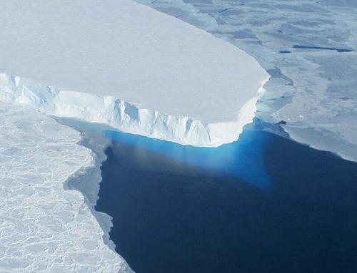
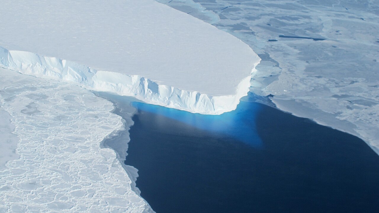
It is a mysterious world, where water running on the surface of the glacier disappears through cracks and holes in the glaciers, and powerful rivers emerge from the glacier snout[1]. Beneath the Antarctic Ice Sheet, these subglacial drainage channels are connected to numerous subglacial lakes[2, 3].

The flow of water at the ice-bed interface has important implications for glacier flow, as saturated subglacial sediments have a low shear strength, and deform easily (see Glacial Processes). Glaciers may also slide over water-saturated subglacial sediments.
Glacier ice is permeable[1], with a network of microscopic veins and lenses of water[4]. The rate at which water percolates through the glacier is dependent on salinity, pressure and temperature. Meltwater percolates only very slowly, and variations in the rate at which it is able to seep through the ice results in ponded water within and beneath the ice sheet. The rate at which ice seeps through the ice, however, is so slow, that for practical reasons ice can generally be considered impermeable[1].
In the next sections, we will discuss supraglacial, englacial and subglacial hydrology with particular reference to Antarctic glaciers.
Supraglacial hydrology
Supraglacial (surface) water on a glacier is formed by the ice melting during the summer. It flows off the glacier, incising a number of cracks similar to an ordinary river system[1]. These channels are often sinuous, and the water can flow at rates of up to several metres per second.
Surface melt (ablation) occurs in the hard-packed snow (firn; the transitional state between snow and ice), and can pond above the impermeable ice. If the firn becomes saturated all the way to the surface, it becomes a ‘swamp zone’, with puddles of standing water. The swamp zone moves up glacier as the melt season progresses. The surface drains increasingly quickly as more ice is exposed, and the firn is filled with water[1]. In Greenland, large lakes form on the surface of the ice sheet during the summer.
However, in Antarctica, much of this saturated firn refreezes, making little overall contribution to melt runoff[5]. Much of the meltwater runoff in Antarctica is restricted to coastal areas and ice shelves during the summer seasons. Saturated firn on ice shelves may facilitate ice shelf collapse[6]. See photographs of meltwater ponds on McMurdo Ice Shelf.
Englacial hydrology
Structures in the ice produced by tension, such as crevasses, allow the water to penetrate into the ice. There are some great examples of this in Greenland, where large lakes can abruptly drain into the ice sheet. Moulins are vertical shafts cut by the water. Water cascades down these into the ice sheet. Despite the pressures within the ice sheet, moulins remain open by constant melting by the water[1]. Finally, there are numerous water pockets and channels within temperate ice sheets[4] and glaciers, where water can remain trapped for some time.
Subglacial hydrology
Subglacial hydrology is critically important in understanding the flow of Antarctic glaciers. Basal meltwater flows through large subglacial hydrological networks[7], which can impact glacial erosion and ice velocity. Some of these channels can be followed for hundreds of kilometres. There is evidence that this hydrological system is very variable, with changes within the glacier bed observed underneath Antarctic ice streams[8].
Meltwater reaches the base of ice sheets through basal melting from geothermal heating and by ice melting under pressure from the weight of the ice mass above. Secondly, downwards percolation and flow of supraglacial and englacial systems. There are several main aspects of the basal hydrological system. Firstly, water can be ponded in subglacial lakes. It can also flow through subglacial channels. R-Channels are incised upwards into the ice. Channels can also be incised into the bedrock or subglacial sediments (Nye channels).
Proglacial drainage
The proglacial area of temperate glaciers is characterised by abundant meltwater runoff from the glacier. Often, this becomes impounded in the overdeepened glacier basin as a proglacial lake. Abundant meltwater can form large braided river plains, or sandur. Runoff is less in Antarctica, and meltwater in the northern Antarctic Peninsula tends to be restricted to small braided streams. These streams, which are part of the paraglacial environment, move and redeposit glacial sediments and rework glacial landforms.
References
- Cuffey, K.M. and W.S.B. Paterson, 2010. The Physics of Glaciers, 4th edition: Academic Press. 704.
- Siegert, M.J., S. Carter, I. Tabacco, S. Popov, and D.D. Blankenship, 2005. A revised inventory of Antarctic subglacial lakes. Antarctic Science, 17(03): 453-460.
- Smith, B.E., H.A. Fricker, I.R. Joughin, and S. Tulaczyk, 2009. An inventory of active subglacial lakes in Antarctica detected by ICESat (2003-2008). Journal of Glaciology, 55(192): 573-595.
- Fountain, A.G. and J.S. Walder, 1998. Water flow through temperate glaciers. Review of Geophysics, 36: 299-328.
- Irvine-Fynn, T.D.L., A.J. Hodson, B.J. Moorman, G. Vatne, and A.L. Hubbard, Polythermal glacier hydrology: a review. Reviews of Geophysics, 49(4): RG4002.
- Scambos, T., H.A. Fricker, C.-C. Liu, J. Bohlander, J. Fastook, A. Sargent, R. Massom, and A.-M. Wu, 2009. Ice shelf disintegration by plate bending and hydro-fracture: Satellite observations and model results of the 2008 Wilkins ice shelf break-ups. Earth and Planetary Science Letters, 280(1–4): 51-60.
- Remy, F., rique, and B. Legresy, 2004. Subglacial hydrological networks in Antarctica and their impact on ice flow. Annals of Glaciology, 39: 67-72.
- Smith, A.M., T. Murray, K.W. Nicholls, K. Makinson, G. Ađalgeirsdóttir, A.E. Behar, and D.G. Vaughan, 2007. Rapid erosion, drumlin formation, and changing hydrology beneath an Antarctic ice stream. Geology, 35(2): 127-130.

Support Earth Climate

About the Author: EARTH CLIMATE
Newsletter
Recent Comments
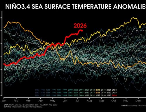
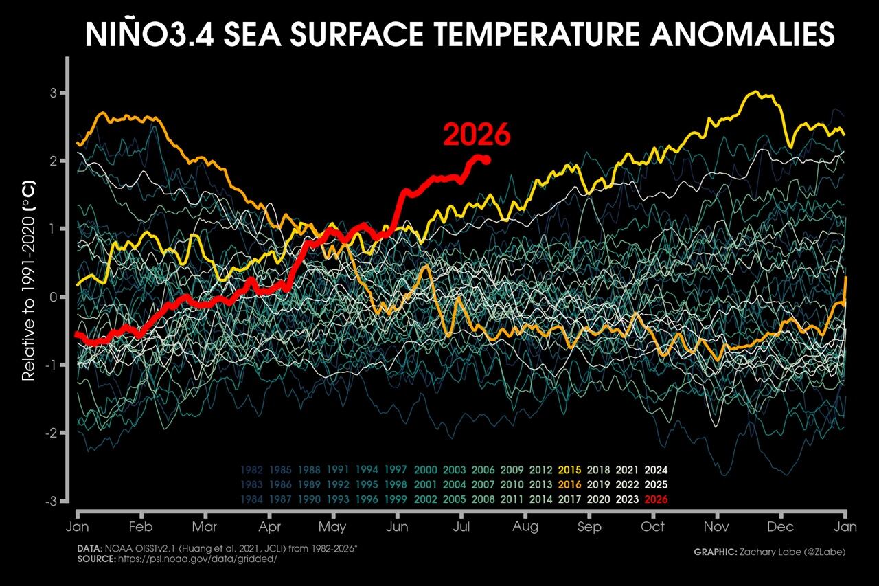
- Extreme Temperature Diary- Saturday July 18th, 2026/Main Topic: The “Super” El Niño of 2026: Why 2027 Will Be a Year That Is Off the Chain Hot – Guy On Climate on The “Super” El Niño of 2026: Why 2027 Will Be the Year the World Watches
- Gemma on The “Super” El Niño of 2026: Why 2027 Will Be the Year the World Watches
- Haiku on Breakthrough in Measuring Methane Emissions
Support
We create visually compelling, accessible science content that transforms complex research into engaging videos and articles, helping millions understand the discoveries shaping our world. [Paypal | Patreon]